Could a flowering verge, a better-planted barrel or a gap between neighbouring gardens help connect Corstorphine’s green spaces? This map gives us a way to explore those questions together.
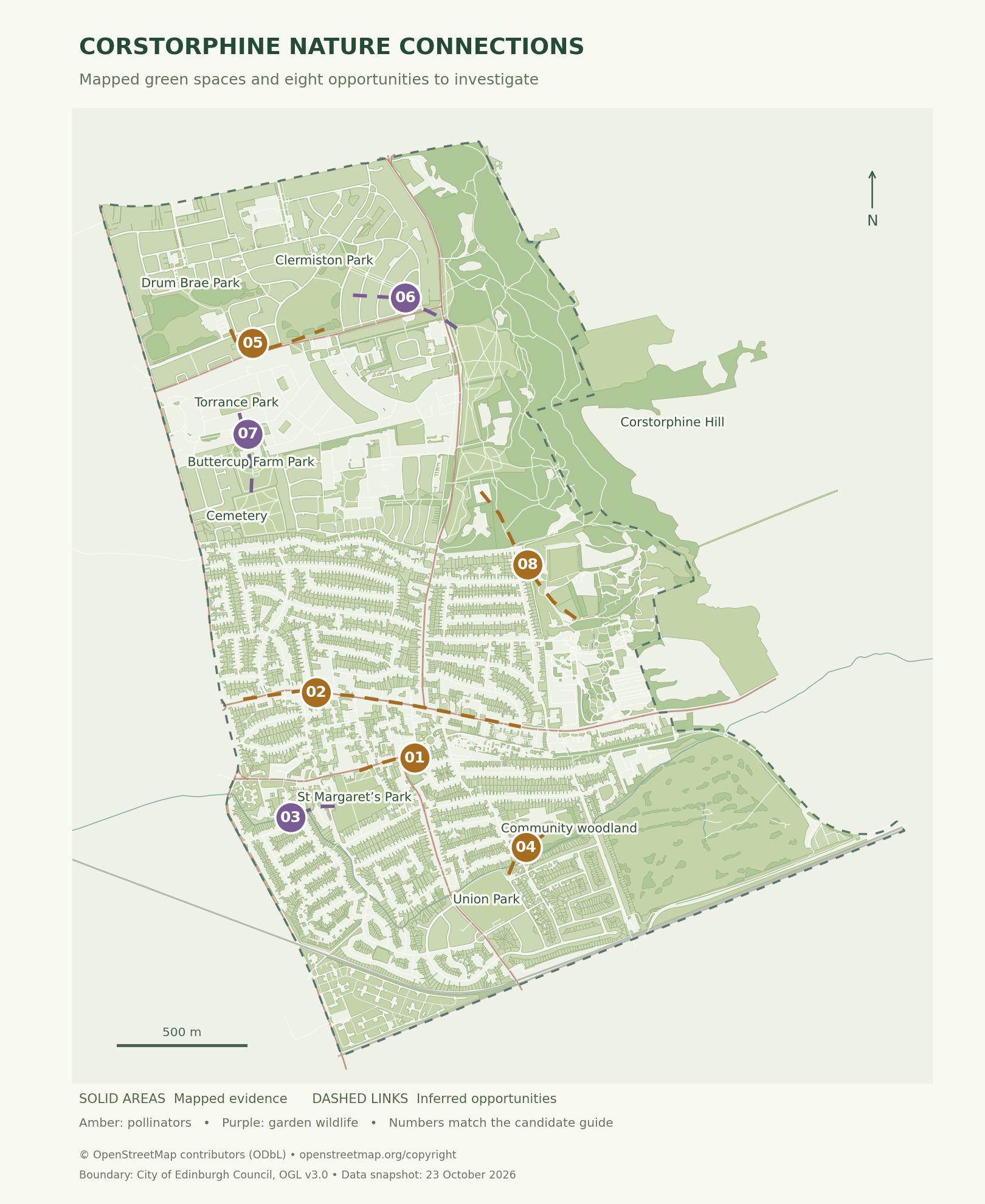
It brings together mapped parks, woodland, gardens, growing spaces, roads and boundaries across the Corstorphine and Clermiston community council area. Eight suggested connections identify places where a site visit and a conversation with local people could help us decide what to do next.
This is a working map, not an approved scheme. Solid features come from open mapping records. Dashed links are opportunities to investigate; they are not surveyed wildlife routes or official Buglife B-Lines.
How to use the map
- Open Layers to switch green spaces, gardens, school grounds, potential barriers and candidate connections on or off.
- Select a numbered connection to see the idea, the mapped anchors, possible interventions and the checks still needed.
- Use the pollinator or garden wildlife filters to explore different types of connection. Zoom in to inspect individual mapped walls and fences.
- Add useful ideas to your shortlist and write field notes. Notes stay in that browser; export a copy if you want to keep or share them.
Pollinator stepping stones
Parks and woodlands provide important green anchors, but the smaller spaces between them matter too. Suitable planters, gardens, hedges and verges could add flowers through more of the year. The map helps us look for places to improve that sequence. It does not demonstrate that the flowers already form a functioning corridor.
For business planters, the first step is an inventory: exact locations, plant species, flowering periods, watering and the person looking after each one. That will let us identify useful gaps rather than simply add more containers.
Garden links and hedgehog highways
The purple candidates identify neighbourhoods where interested residents could investigate connected garden habitat. A garden shape on a map does not tell us whether its fences are passable or whether hedgehogs use it.
Hedgehog Street suggests openings of about 13 × 13 cm between suitable neighbouring gardens. Any change needs the owners’ agreement and a check that it will not direct animals towards traffic. Busy-road crossings need separate advice.
From a map to practical action
- Walk a candidate area using public routes and record flowers, cover, mowing, lighting and barriers.
- Talk to residents, businesses, park groups and the relevant land managers.
- Check permission, pavement access, sightlines and a realistic maintenance arrangement.
- Agree a small intervention, record the starting conditions and review what changes.
The evidence behind it
The base information comes from OpenStreetMap and the City of Edinburgh Council’s community council boundary dataset. The approach takes account of the Edinburgh Nature Network and links to guidance from Buglife and Hedgehog Street. The Council’s official action polygons and Buglife’s official B-Lines are not imported into this map.
The open mapping snapshot is dated 23 October 2026. Missing mapping does not mean there is no habitat, and the suggested connections still need checking on the ground.
This is part of our wider Climate & Nature Action.

